bbsoft - planning to the point
Were your reliable software partner for infrastructure solutions in civil engineering. With BBSoft, you can realize projects efficiently, future-proof, and with planning certaintyno detours, no complications. Were by your side when it really counts.
 BIM in civil engineering
Learn more about building information modeling (BIM) in civil engineering and how you can use BBSoft® in your digital construction projects in the best way.
 Surveying
Our base software for importing measuring data of current device manufacturers, for mapping and for compiling of location plans.
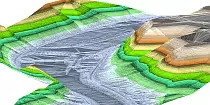 Digital Terrain Model
With BBSoft® you can compile quickly a DTM from terrain data, points (laser scan data also) and breaking edges.
 Road planning
The software fulfills all current requirements in road planning, especially in site development, in redevelopment and in the design of intersections.
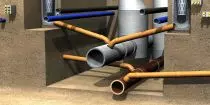 Sewer and water networks
The complete solution for planning, hydraulic calculation, redevelopment and condition classification for sewer and waterline networks.
 District heating
Energy-efficient, environmentally friendly, and reliable: Design the heating supply of tomorrow with our planning software. District heating up close.
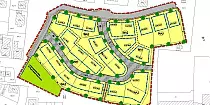 Urban planning
You can edit your master- and urban plans quickly and easily under consideration of the standard for map symbols.
 Calculation of quantities
You can automatically record, calculate and manage your masses and areas with the help of check routines with BBSoft®.
 GIS
GISOur GIS-information system for engineering offices and communes makes it possible to access upon information and to induce own application modules.
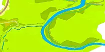 Water planning
Software for the sectors dike- and water planning plus high tide simulation with interfaces for the hydraulic calculation.
 Cadastre ALK/ALKIS
It´s possible to convert your parcels of land - and your owner information into high-quality CAD-data or to import these into the cadastre information system.
 Company
As leading provider for civil engineering software, we have covered a long distance since the foundation of our enterprise 35 years ago.
What people say ...

“For more than 15 years, we are effectively working with the customer oriented solutions of BBSoft on our projects. The individual support, annual updates associated with workshops and an excellent hotline with short response times characterize BBSoft. With a good conscience we can recommend the solutions of BBSoft. Keep it up!”
Dipl.-Ing. (FH) Bauwesen Achim Förster,
CEO Ingenieurbüro Förster, Villingen-Schwenningen (GERMANY)
“For about a year now we are working with the software BBSoft. Because of the good BBSoft-support and the simple operability, the switch developed smoothly. The program was quickly accepted from all employees and utilisied versatilely after a short period of familiarization. Also small features, like clash validation and a Shape-interface (which was quickly made available upon an urgent request), played a part in contributing to our good experience with the software BBSoft. Especially the performance-orientated design of the software, the easy operability of the different modules and also the varied applicability convinced us. We are very pleased, that our questions are always answered rapidly and qualified at the BBSoft-Hotline. Special thanks to the competent and patient teams in Austria and Germany.”
Dipl.-Ing. Johannes Längle,
ADLER + PARTNER ZT GmbH, Vorarlberg (Austria)
“For us BBSoft is especially characterized by the excellent support-team, beside the easy and self-explaining usage of the software. Our concerns and support-requests were always recorded, understood and equally rapid they came up with a solution. With the very knowledgeable employees the hotline creates an enormous added value for the software. BBSoft contrasts clearly to the competition, also in the matter of cost-benefit ratio towards comparable software.”
Abdullah Yalin,
gpw Wälter Willa, Ingenieure für Geomatik Planung Werke, Affoltern a.A. (Switzerland)
“We make use of the software of BBSoft for the structurally engineered condition classification and -evaluation of sewer. The automated classification of object classes facilitates immensely the evaluation of condition. An uncomplicated creation of plans is possible, via the integration of the BBSoft-module into a CAD-system. A simple data export leads to a quick determination of the total redevelopment costs. The telephonic support of BBSoft is always very well reachable. The proficient employees attend comprehensively to the questions and concerns and implement improvement suggestions and software developments promptly. Thank you for the good cooperation.”
Dipl.-Ing. (FH) Günther Schmid ,
RAPP + SCHMID Infrastrukturplanung GmbH, Ummendorf (GERMANY)
“Since 1995 we are working with the software of B&B and in most modules, the prices have remained approximately the same (considering the changeover to the euro), although the modules have been even further enhanced and improved over the years. The software covers a broad range of civil engineering planning, so that you usually don`t have to switch between BBSoft and other products. If problems occasionally occur, you will encounter at the hotline on friendly and capable assistants, who provide solutions in the shortest time. Keep up the good work!”
Dipl.-Inform. Jürgen Knoll,
Ingenieurbüro Funk GmbH, Riedlingen (GERMANY)
“For more than 10 years we are using BBSoft at different locations, predominantly in the areas of road construction, sanitary and environmental engineering, water engineering and engineering surveying. The planning in these areas has become unconceivable without such civil engineering software. This follows from the time saving, which is enabled from the software for us. We appreciate the orientation at customer requirements as well as the problem-free accessibility of the support.”
Dipl.-Ing. Thomas Zimmermann / Maik Beysel,
Weber-Ingenieure GmbH, Darmstadt, Essen, Freiburg und Pforzheim (GERMANY)
“We have gained very good experiences with BBSoft with the training as well as the support. BBSoft is not a cheap solution but in our view the most economic. Seven years ago i was in search of an useful solution for my office and tested out the complete range for the german market. We are landed by BBSoft and so far we have totally no regrets about this decision. All of my employees had a two-day training and after this they worked immediately with the software. So far no one has expressed the wish for a reactivation of our previous software solution.”
Gunnar Hirsch,
Ingenieurbüro Hirsch, Oldenburg (Germany)
“The cooperation with BBSoft is extremely pleasant and pragmatic. The colleagues at BBSoft contrive to find quick and customer oriented solutions, so that we can implement our projects quickly and high-graded.”
Wolfgang Schabauer,
Rusaplan GmbH, Gloggnitz (Austria)
“In 2015 we decided to switch to BBSoft because we weren't satisfied with the support and different program modules of our present software, although we only worked 3 years with this previous program. The employees of BBSoft supported us in an excellent way through the whole migration phase. Suggestions for improvement were implemented prompt and optimally, geared to our needs. The employees at the support are always contactable and we feel in very good hands. Change of software was a complete success for our office. We are wishing for a long-lasting, successful and fair cooperation with the whole team of BBSoft.”
Lilli Klein,
a2Plan Ingenieure GmbH, Westhausen (GERMANY)
“From day one BBSoft provides valuable support. Hardly one minute goes by, until the support has a suitable solution ready. Furthermore it will be contemporary responded to customer requirements and improvements of the software. In contrast to other products BBSoft lays the focus on current functions, which are without any great effort quickly and flexible adaptable.”
Dipl.-Ing. Christoph Wutz,
Ingenieurbüro Wutz, Painten (GERMANY)
“For over 20 years we have decided to work with BBSoft and are still satisfied that we have found the right partner in relation to CAD-software civil engineering and GIS (geographic information system). Thank you so much for the simple and uncomplicated way to work with you.”
Michael Jouaux,
Ingenieurteam Michael Jouaux, Grünsfeld (GERMANY)
Partner